Air raid shelters (page still under development)
As war threatened, the Council began digging trenches for protection against air raids. Amongst the first dug was at St Johns School in Roseland Road, but this was almost immediately filled in as it posed a danger to the children! (The school was later provided with a surface shelter). Extra staff were taken on to dig the trenches and a number were completed with others planned by the end of 1938. In May 1939 there was a change of direction and contracts for “the concreting and otherwise making permanent the trenches in Kenilworth” were signed.
Kenilworth is known to have had at least sixteen public and school air raid shelters constructed and several survive, more or less intact, on the perimeter of the Abbey Fields and in New Street. Of the surface shelters, one in Henry Street was used post-war by the still-existing Kenilworth Wheelers cycle club as a club room, and another in Dalehouse Lane was used by a radio club. On 12th February 1952, the Kenilworth Urban District Council agreed that Mr Castle of Mill End should be paid £90 for bricking up the entrances of the others.
In January 1969, the Council received a circular from the Home Office saying that all surviving air raid shelters were to be retained unless they were unsound, a danger to health or in the way of development. This led to those at Hyde Road (known as unhygenic before it was bricked up) and the Arthur Street / Spring Lane junction that was partly above ground, being demolished. The three in the Abbey Fields and at New Street were not seen as being a problem and so survived, as requested by the Home Office, in case they were again needed.
Members of the Kenilworth History and Archaeology Society have carried out some admirable research on this subject, erecting a plaque at the entrance to the shelter in Bridge Street, and I can recommend their leaflet ‘Kenilworth in World War II’ that includes photographs taken inside that shelter.
In July 1941, the KUDC drew up a list of the town’s public air raid shelters, and added ten new ones as proposals:
Existing shelters, public:
1 Opposite the castle entrance
2 North side of New Street in Martins Fields
3 West side of Bridge Street near traffic lights
4 West side of Rosemary Hill near Abbey Hill
5 North side Forrest Road near junction with Borrowell Lane
6 West side of The Square near Borrowell Lane
7 East side of Warwick Road near Bear & Ragged Staff
8 East side of Warwick Road immediately north of St John’s church
9 South side of Station Road adjoining the cinema
10 At junction of Arthur Street and Spring Lane
11 In arch formation under Park Hill Road, access from south side of road
Existing school shelters to be used in an emergency:
12 Two on south side of school, School Lane
13 Two south side of school, Priory Road
14 South side of school, Roseland Road
Proposed new shelters:
15 Red Lane, west side near stores
16 Crackley Hill, Coventry Road, east side and 75 yds south of railway bridge
17 Dalehouse Lane, south side and east of entrance to Watling Road
18 Hyde Road on north end of green
19 Albion Street, in carriageway, on west side and about 150 yds from south entrance
20 Henry Street, on land on west side about half way along
21 Arthur Street, on east side about 200 yds from junction with Spring Lane
22 St John’s Street, on council land at west end of street
23 Roseland Road, on land north side of road near top of Moorlands Avenue
24 Moseley Road on land on west side opposite Worcester Road
 |
 |
 |
| Shelter 1, Castle entrance | Shelter 2, North side of New Street in Martins Fields | Shelter 3, West side of Bridge Street near traffic lights |
 |
 |
 |
| Shelter 4, West side of Rosemary Hill near Abbey Hill | Shelter 5, North side Forrest Road near junction with Borrowell Lane | Shelter 6, West side of The Square near Borrowell Lane |
 |
 |
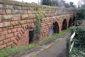 |
| Shelter 9, South side of Station Road adjoining the cinema | Shelter 10, At junction of Arthur Street and Spring Lane | Shelter 11, In arch formation under Park Hill Road, access from south side of road |
 |
 |
 |
| Shelter 13, school, Priory Road
(Aerial photo by John Webster, courtesy of his son, Stephen) |
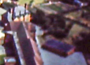
Shelter 14, St Johns School
The shelter can be seen underneath the tree. The tree survives and the rectangle of the shelter is today occupied by play equipment |
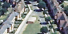
Shelter 18, Hyde Road on north end of green
(Aerial photo by John Webster, courtesy of his son, Stephen) |
 |
||
| Shelter 20, Henry Street, on land on west side about half way along. 48 Henry Street occupies the spot today |
For private air raid shelters, follow this link: Private air raid shelters